
Introduction
The New Media Consortium predicts the sharply rising use of Augmented Reality (AR) in higher education over the next five years. As with any new technology, I am always interested in how AR can be made viable for busy instructors – so that a reasonable effort yields a commensurate return. I’ll introduce a prototype project that can be replicated by instructors. But first, let’s take a broad look at AR.
Augmented Reality covers a wide spectrum of applications, which is reflected in the consortium’s description of AR as “the incorporation of digital information including images, video, and audio into real-world spaces. AR aims to blend reality with the virtual environment, allowing users to interact with both physical and digital objects.” (NMC, Horizon Report, 2016 Higher Education Edition)
In this article I walk through the making of a simple AR application with the LodeStar authoring tool, which now includes the ARMaker template. Any intrepid instructor can create something similar for his or her own course.
Our use of AR fits closely with a common use that is defined by a research article that appeared in Computers and Education in March 2013, titled “Current status, opportunities and challenges of augmented reality in education”
First, AR technologies help learners engage in authentic exploration in the real world, and virtual objects such as texts, videos, and pictures are supplementary elements for learners to conduct investigations of the real-world surroundings (Dede, 2009). One of the most prevalent uses of AR is to annotate existing spaces with an overlay of location-based information (Johnson et al., 2010a).
AR supporters make claims of deeper engagement of students, connection of academic content to ‘real world’ and deeper levels of cognition. TechTarget’s definition of Augmented Reality is that it is the “integration of digital information with the user’s environment in real-time. Unlike virtual reality, which creates a totally artificial environment, augmented reality uses the existing environment and overlays new information on top of it. “
You have already seen AR applications outside of education:
In watching football, you’ll notice the yellow first down line painted across the television screen. That has stuck as a useful and accepted addition to the game. Other ideas were not so well received. Fox Sports glowing, streaking hockey puck was the culmination of a $2 million R&D project that got hockey fans…well, glowing mad.
More relevantly, in education, teachers use technology to create their own “auras” around, for example, works of art that suddenly come to life when scanned with the mobile phone camera. An aura can cause music to play, or a video to show, or an animation to display. Math students can point their smart phone at an equation and watch it jump to life on the screen (Aurasma).
The QR tag is a simple form of Augmented Reality. Special QR reader apps enable museum visitors, for example, to scan a QR tag and launch a web site devoted to the art exhibit and its interpretation. JISC, formerly the Joint Information Systems Committee and now a non-profit company, describes a project in England where students scan rare manuscripts with their smart phones and have digital facsimiles appear so that they can turn the pages and get supporting videos, text and images to help them interpret the old texts.
Finally, the University of Oklahoma library created a smart phone app that guides visitors by sensing their physical location, and revealing information about nearby content resources. They placed Bluetooth beacons in strategic places. The beacons are set to transmit data at regular intervals. The smart phone receives the beacons’ unique id and as a result knows precisely where it is and what content should be displayed. Out of doors, the application uses GPS and the smart phone’s location services.
Imagining the Possibilities at a Simpler Level
I recently chatted with an environmental science professor at our university. Near our main campus we have a wonderful natural treasure called Swede Hollow. Swede Hollow is a wooded ravine at the foot of Dayton’s Bluff in East Saint Paul. Poor immigrant families settled in the hollow starting in the late 1800s. Phalen Creek once ran through it in full force. At the top of the bluff stood the Hamm’s Mansion until it burned down in the 1950s. At one end of the hollow stood the Hamm Brewery.
Swede Hollow is rich with historical, geological and natural interest. Of course, the environmental science prof had the knowledge to uncover the layers of significance of this area. We discussed a mobile application that would do just that. Students could visit the area with their cell phones and be presented with location-specific information that may not be readily apparent to the casual observer. For example, Phalen Creek is now “entombed’ in an underground tunnel that has attracted a following of urban adventurers.
The instructor has led student tours through Swede Hollow. On her tour, she mentions the changing appearance of trees during the seasons or the tunnel underneath and promises to show the imagery of urban adventurers when students return to the classroom. It is difficult to replace her personal touch with a digital application, but in terms of information and the display of digital assets, in an augmented reality application, the instructor’s expertise could be captured and presented to the students at specific locations. Students would be able to take the tour at their leisure – in a sense, asynchronously — spending more or less time at each location according to their interest. The dependency on the instructors’ availability would be removed.
About twenty miles from Swede Hollow is my home town – Stillwater, Minnesota. That’s where the story of our first prototype begins.
A working prototype
Stillwater is also rich in history, geography, plant and animal life, and politics. The same is true of many areas, and yet we pass through them at fifty miles an hour oblivious to the layers of interest that surround us or… remotely contemplate them from our computer terminal – perhaps in the context of an online learning class.
In Stillwater, we have the history of the saw mills, the bursting of a dam that sent tons of mud and debris down a ravine to reshape the downtown, the sandstone and limestone bluffs, the restoration of prairie grasses and oak savannas along the river, the wildlife, the reign of the lumber barons and the Victorian architecture. As in any area, all of this can be lost on the casual observer.
A walking tour can get us out of the car or away from the computer and into the world – aided by a smart phone and the captured knowledge of an educator like our environmental scientist.
Educators know the points of interest. Depending on their discipline, they know the civil rights history of an intercity area; they know the trees, and plants and shrubs featured in a tucked away ravine; they know the source and destination of streams. With the help of technology, they can now tell their story to all who are interested in a manner unprecedented.
Of course, education aside, Pokemon, portals and anomalies have gotten people out of their chairs and into the world. The company Niantic created Ingress and Pokemon Go to get people away from the game consoles and wandering about their neighborhood and cities in search of game features that are tied to locations through latitude and longitudinal coordinates. In the case of Pokemon Go, gamers are in search of uncaptured Pokemon that are found at specific locations. Gamers must physically go to those locations. In the case of Ingress, gamers find portals that they try to either destroy or restore. In both games, people move about with their smart phones, going to locations, causing the app to display something of interest.
In contrast, the type of interaction that we propose is simpler but rooted in the richness of a particular discipline. We propose something that instructors can create with the help of a template and a little creativity. Students are led on a guided tour of an area where they are introduced to the history or geography of that area or whatever matches the discipline. They are guided from point to point. Their instruction comes from observing the physical thing and hearing or reading about its significance or challenged to take notes and draw conclusions from their observations or any variation thereof.
In the project that we are building as a proof of concept, we explore the history of Stillwater. The City of Stillwater has already produced a walking tour. It is well done with vetted historical content and professionally produced media. Currently, visitors can access the Historic Downtown Walking Tour website and view each location from the convenience of their computers.
We propose that students travel to the location and experience all of the sights, sounds and smells of the location in addition to learning about its significance.
The current tour is concentrated in downtown Stillwater both east and west of Main street.
In our prototype, students are guided to a location and then given information on how to find the next location. In the following screen shots from the prototype, students start at the pergola by the river. Once there, they can access an audio presentation on the preservation efforts at the turn of the last century and the resulting Lowell Park. They are then guided to a mill, old freight house, caves that stored beer kegs, and more.


We created the prototype by launching LodeStar and selecting the ARMaker template. For each page we put in the precise location with the help of Google Maps and a Google Earth overlay. For each page, we inserted images, typed text and imported audio that was matched to the location. In the future, you will see the results of this project. We are awaiting permission from the city council for this ‘proof of concept’. In the meantime, we can tell you some of the benefits and challenges of designing this prototype.
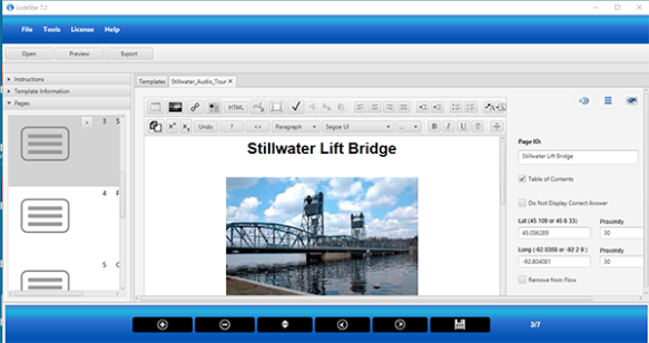
Matching content with Latitude and Longitude Coordinates with LodeStar
Lessons Learned
The theme of the Stillwater walking tour is the ingenuity of humans to eke out their livelihoods from the natural resources of the area: lumber, wheat, and beer, to name a few. The walking tour covers the triumphs and the trials of the various local businesses and enterprises. It’s a sneak peek into the past.
To date, we learned several things from creating this walking tour. We’ll list some of the more important lessons:
- Stay out-of-doors. Accurate locations come from GPS satellites. The results indoors will vary greatly depending on the location. When GPS is unavailable, locations are achieved through other, less reliable means. Whereas the GPS signals can give us coordinates that are two or three meters off target – in other words, fairly precise – alternative means may give us imprecise coordinates, which may be dozens of meters off target.
- Add a fudge factor. Set the location with a proximity of 40 feet. That means, when the students are within forty feet of the target, the content will display/play. 40 feet may seem like a wide radius, but once students are on a field trip and approaching landmarks, 40 feet is not a large distance at all.
- Make it easy for students to know where the next location is. Have students follow a street or a path or a riverbank. Alternatively, give precise directions to the next stop.
- Use text, images and audio. Video can pose a problem. Students will be connected through 3G or 4G. The data rate for 3G is 2 Megabits per second. The data rate for 4G is 20 megabits per second or higher. 10 times faster. The experience will be quite different for the two users.
- Use simple questions to check students’ understanding at a site, with feedback.
- Be careful of making students walk great distances without frequent points of interest.
- Consider visual and hearing impairments when designing the application
- Be mindful of students who can’t walk great distances. Distances are short on a map, but not in the field. Consider, an alternative, shorter tour.
- Instruct students to first load the project website into their browser when they have a good connection to the internet so that images and audio can get cached, resulting in a better playback experience for students.
- When producing a self-guided tour, use Google maps on the desktop to set locations with at least six digit precision. For example, 45.094156. Google maps will allow you to zoom into a location and click to set a marker. Overlay Google maps with Google Earth to know where you are and get very accurate locations. Copy the coordinates of the marker into your application. If you must walk the tour to set locations, download an app that gives you good coordinates. An example app would be LocMarker Lite, which allows you to add and record locations with six digit precision. The compass on the iPhone, conversely, gives you coordinates in degrees, minutes and seconds, which is not enough resolution. A second of latitude is 80 feet.
Why it works
When we hear, see, read, discuss and reflect upon things we are encoding information and experiences in semantically rich ways that help in the retrieval of this experience and relating it to other knowledge. We experience the moment, the sights and smells. We note the texture of the object, its placement, its size and we ponder the relationship of some newly presented content to this tree or building or river way.
Augmented Reality can also challenge us to think critically about what we are seeing. I remember when I was a boy going on a technology-assisted field trip that I will never ever forget. The technology was the orienteering compass. We moved from location to location by being given a directional bearing and a number of paces. One of the locations was a tree that was obviously diseased. We were challenged to identify the disease and then introduced to Dutch Elm disease. I had never known the devastating effects of disease on trees ….and recalled the experience later in life when our own woods were ravaged by oak wilt.
Conclusion
This is a first attempt at AR. We have already published the ARMaker template with the latest release of the LodeStar eLearning authoring tool. You can download the trial version and immediately access the ARMaker template. Try it for your own class and give us feedback on how you designed your walking tour. Eventually, we will propose an AR assisted walking tour design pattern that reflects best practice.
Download LodeStar at http://www.lodestarlearning.com Look for the Try link at the top for the trial version. Select the ARMaker template.
Happy exploration.
